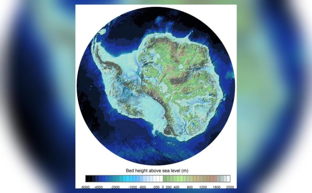
Pic Shows ‘Most Detailed Map’ of Landscape Under Antarctic Ice
The frozen landscape of Antarctica has long been a topic of fascination for scientists and explorers alike. For years, researchers have been working to uncover the secrets that lie beneath the continent’s massive ice sheets, and a recent breakthrough has yielded the most detailed map of the landscape under Antarctic ice to date.
The British Antarctic Survey (BAS)-led project, which employed advanced imaging techniques such as radar and other specialized tools, has produced a stunning visual representation of the deep valleys and mountains that lie hidden beneath the ice. By removing the 27 million cubic kilometers of ice that cover the continent, the team was able to reveal the underlying landscape in unprecedented detail.
The newly mapped terrain is a crucial step in understanding the continent’s layout and the processes that shape it. The map also highlights critical lines where the ice meets the ocean, providing valuable insights into the dynamics of the Antarctic ice sheet.
So, what lies beneath the 16,000 feet of Antarctic ice? The BAS-led project has given us a glimpse into a world that was previously unknown, and the results are nothing short of breathtaking.
The map, which covers an area of approximately 15,000 square kilometers, reveals a landscape that is both familiar and alien. The team discovered deep valleys and towering mountains, some of which stretch over 1,000 meters above the surrounding terrain. The valleys, which were formed by ancient rivers and glaciers, are a testament to the region’s complex geological history.
One of the most striking features of the map is the discovery of a vast network of rivers and lakes that lie beneath the ice. These waterways are thought to be remnants of a time when Antarctica was a much warmer and wetter continent, and they provide valuable insights into the region’s ancient climate.
The team also identified several areas where the ice sheet is thinning, which is a critical factor in understanding the continent’s response to climate change. The BAS-led project has been monitoring the ice sheet’s health for years, and the new map provides valuable insights into the processes that are driving its changes.
So, how did the team achieve this remarkable feat? The answer lies in the use of advanced imaging techniques, such as radar and seismic surveys. These methods allow researchers to penetrate the ice and create detailed images of the underlying terrain.
The radar technique, which uses radio waves to image the ice, was particularly effective in revealing the continent’s hidden landscape. The team used a specialized radar system, which was mounted on a sled and towed behind a snowmobile, to create detailed images of the terrain.
The seismic surveys, which involved sending shockwaves through the ice and measuring their reflections, provided valuable information about the underlying geology. By analyzing the reflected signals, the team was able to create detailed maps of the terrain and identify areas of interest.
The results of the BAS-led project are not only a testament to the power of advanced imaging techniques, but also a reminder of the importance of continued research into the Antarctic ice sheet. As the continent continues to respond to the impacts of climate change, it is more important than ever that we understand the underlying dynamics that shape its landscape.
The new map is a crucial step in this process, and it has the potential to revolutionize our understanding of the Antarctic ice sheet. By revealing the secrets that lie beneath the ice, the BAS-led project has given us a glimpse into a world that was previously unknown, and it is a reminder of the importance of continued exploration and discovery.
As we continue to explore the frozen landscape of Antarctica, we are reminded of the awe-inspiring beauty and complexity of the natural world. The new map is a testament to the power of human curiosity and ingenuity, and it is a reminder of the importance of continued research and exploration.
In conclusion, the recent breakthrough in mapping the landscape under Antarctic ice is a remarkable achievement that has given us a glimpse into a world that was previously unknown. The new map is a crucial step in understanding the continent’s layout and the processes that shape it, and it has the potential to revolutionize our understanding of the Antarctic ice sheet.
The British Antarctic Survey-led project is a testament to the power of human curiosity and ingenuity, and it is a reminder of the importance of continued research and exploration. As we continue to explore the frozen landscape of Antarctica, we are reminded of the awe-inspiring beauty and complexity of the natural world.